Back to territory. Positions and forms of sustainability in Germany edited by Jörg Schröder and Maddalena Ferretti, with Claudia Di Girolamo
torna suNorth sea territory. A cultural landscape in a process of change. Ines Lueder 
This article aims to shed some light on the development of the peripheral community of Dornum - a possible testing ground for the sustainable development of a new rural-urban territory and cultural landscape.
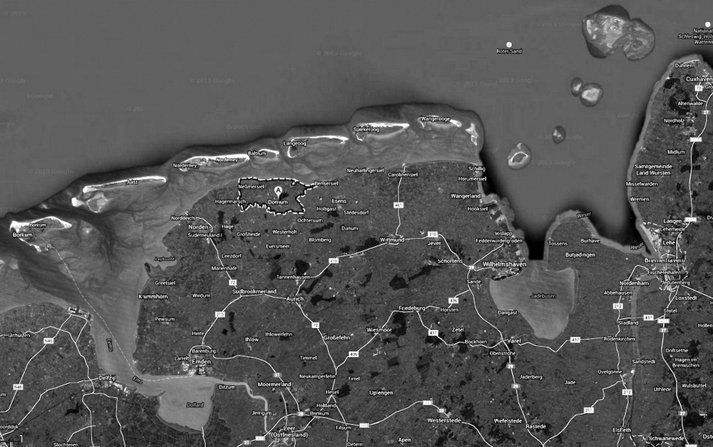
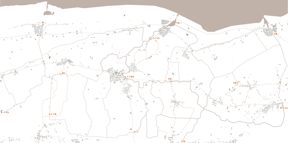
The community of Dornum is located at the shoreline of East Frisia, a part of Germany that belongs to the state of Lower Saxony. On 77 square kilometers, around 4800 inhabitants are living in 10 villages. There are two coastal villages with a harbor and a tidal gate and one central village with an old castle, a church, a town hall and other infrastructures and services. Additionally, several small villages are spread in the countryside. The accessibility is poor. There is no train service, just bus connections and the next highway lies 50 kilometers away. Traditionally the land is used for agriculture. The main soft locational factors are the North and the Wadden Sea as well as the cultural landscape of the marsh lands. These are reasons for seasonal mass tourism. (Images 1 + 2)
The community is undergoing changes. Nowadays we see competing interests for using the ground. We observe an overlay of various stakeholders and an overlay of legislation brought in by the different political layers. Furthermore trans-local dependencies have gained influence on many levels. More than half of the community´s territory is identified as landscape protection area or nature protection area. There are new incomers, changing lifestyles and structural transformations in production and economy. Formerly strong, historically grown relations dissolve. In this challenging situation, the community lacks a vision for future development.
We worked for three semesters with students in the area, doing field research and design projects. Our aim was to understand the circumstances and interdependencies. With this knowledge we were able to contribute to the discussion about possible future visions. Being part of the Faculty of Architecture and Landscape of the University of Hannover, we questioned how urban design, architecture and the processes of planning and building can establish a contemporary relation to landscape. We questioned how these issues can contribute to regional value creation and to sustainable cultural production - in order to generate a sense of identity. We worked on finding material, typological, functional, social and cultural connections to anchor the processes as well as the outcomes of planning and building in the context. We discussed how synergies could be created to raise additional value.
The territory and its founding myth
The land of East Frisia has been, and still is, wrenched from the Sea. In historic times, before the dykes were built, the overlay area of land and water used to be even greater than the present-day Wadden Sea, since a wide surface of marshland was flooded continuously. This historic flooding of land is the reason for the fertility of the soil today. Although nowadays people feel safe in this area, one has to keep in mind, that this territory, situated just at sea level, is an endangered one. Without the technical infrastructures of dykes and drainage it would be flooded.
The historical occupation of the land contributes to a special and distinct local self-concept and cultural landscape. The founding myth of the settlement of the East Frisian marshlands comprises the hand-made territory. The movement of soil was the basis for a save living and for a productive utilization of land. In times without motorized vehicles and machines, one can imagine the efforts and arduousness of this work. Dwelling mounds, piles of earth for singular houses or even agglomerations of houses, were heaped up, often at places lying naturally higher. Just some meters more in height made the difference during a flood. The further development of building dykes fundamentally changed the landscape and allowed a more or less safe agricultural use of the territory [1]. Since the soil has a high fertility, agriculture is a profitable business and good reason for these modifications of the land´s surface. Cutting off land from sea by dykes requires a solution for the sweet water. To achieve dry fields a pattern of drainage channels had to be dug. Since the land lies at sea level, the drainage of rain water has to be executed through tidal gates integrated in the dyke. Hedge banks are another element, which has evolved, in order to divide property and to give protection against wind and erosion. All these elements demand high efforts in construction and maintenance. In former times, the hard work had to be accomplished by everybody owning property and using the land. If one was not able, for whatever reasons, to contribute to the building and maintenance of the dykes, he lost his property. This fact was symbolized by putting the spade in the dyke and leaving the land. This story is still being told today.
Buildings in the cultural landscape
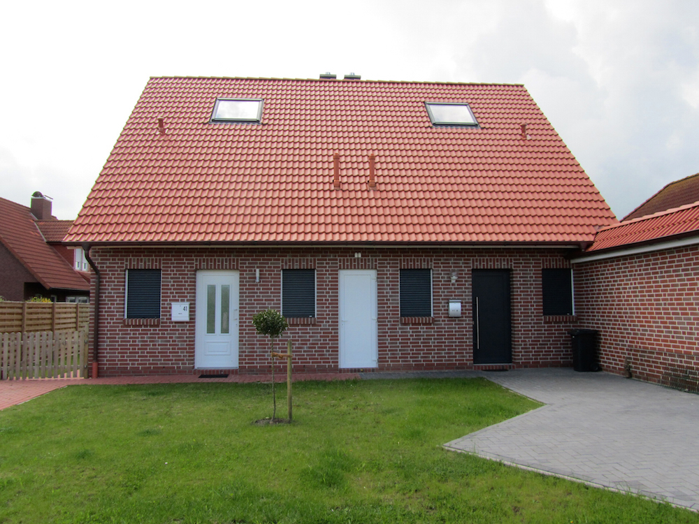
The historical building type of the Gulfhaus, a certain type of farmhouse in East Frisia, illuminates well the conditions of the territory. First of all, the dispersed arrangement of the farmsteads in the territory helps us to estimate the size of agricultural land belonging to a farm. It shows the dense exploitation of the fertile earth and the short distances for man and cattle. The second remarkable character is the dwelling mound, called Warft. As described before, these mounds were hand-made and implicitly necessary to settle in a safe way. The house itself is impressive due to its mere size. It has a two-story living part at the one end and an adjacent huge stable and barn. Building materials were local brick and mortar from mussel chalk. Wood was imported either from inland areas of the Geest, or by ship from Scandinavia. Surrounded by trees, which provide wind protection and foothold for the earth, the Gulfhaus is well visible in the flat landscape.
The impression it gives, is that of pride, wealth and dependency. It gains beauty due to its multilayered relationships with the territory and the resultant readability in space. These farmhouses are expressions of local conditions: At first there is the ground as a productive, but also threatening surface. Furthermore there is the labor of man, modifying the ground to fit his needs and to secure life and harvest. The buildings, which house life and labor, which are constructed by local materials of the ground, constitute a face in the cultural landscape. The Gulfhaus is a materialization of the historic processes of occupation and local dependencies in the cultural landscape. But today the Gulfhaus is an endangered type. Many buildings are uninhabited and exposed to decay: a clear sign of the structural changes in the territory. (Image 3)
Findings of field research
The most stable condition in the community of Dornum is the dynamic system of the tides with an average range of 3 meters, flooding the Wadden Sea roughly every 12 hours. In contrast to this reliable equilibrium, the living circumstances and the cultural landscape are about to change. Assuming that past times were more constant, makes things obviously too simple, since changes have always happened. But it is noticeable, that the territory is not so much closed or self-contained anymore, as it appears to have been in earlier times. Local references and networks dissolve and so does the founding myth of the territory. Instead trans-local influences and networks plus an increasing amount of stakeholders and regulations from various administrative levels, lead towards a situation of major structural transformations and conflicts in land use. The sea, being an essential point of reference and determining factor, influencing the weather conditions and being infrastructural connection as well as harvest ground, has gained additional importance as a recreation area (more than 500.000 overnight stays per year in the community) and as a nature protection site (UNESCO World Natural Heritage Site since 2009): the first increasing the frequency of usage, the latter calling for diminishing human impact.
General transformations in the agricultural sector can be observed locally in Dornum. In Lower Saxony the agricultural land decreased only a little bit from 2.719.072 ha in 1949 to 2.577.017 ha in 2010. But the number of agricultural businesses experienced a major decrease from 291.327 businesses in 1949 to 41.730 businesses in 2010. Roughly only every seventh business still exists. In the administrative district of Aurich, to which Dornum belongs, the average size of land per farm increased 3.5 times in 30 years, from 16 ha in 1979 to 56 ha in 2010 [2]. This development is most obvious in the landscape of Dornum since many of the old farm buildings lie empty. Instead one can find huge new stalls for mass production of livestock and other clustered functional agricultural buildings.
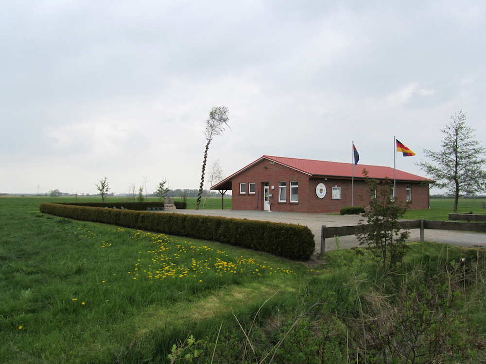
Another transformation of economic cycles and of the landscape is caused by the energy production. Since the territory is highly profitable for energy production, there are around 82 windmills in the community. Being a thorn in the side of conservationists, they also change the impression of the landscape enormously. The flatness, the long straight horizon, has received a vertical counterpart. The struggles around this topic are highly political, intensive and seem never ending. Discussions on visual effects however play a minor role. (Image 4)
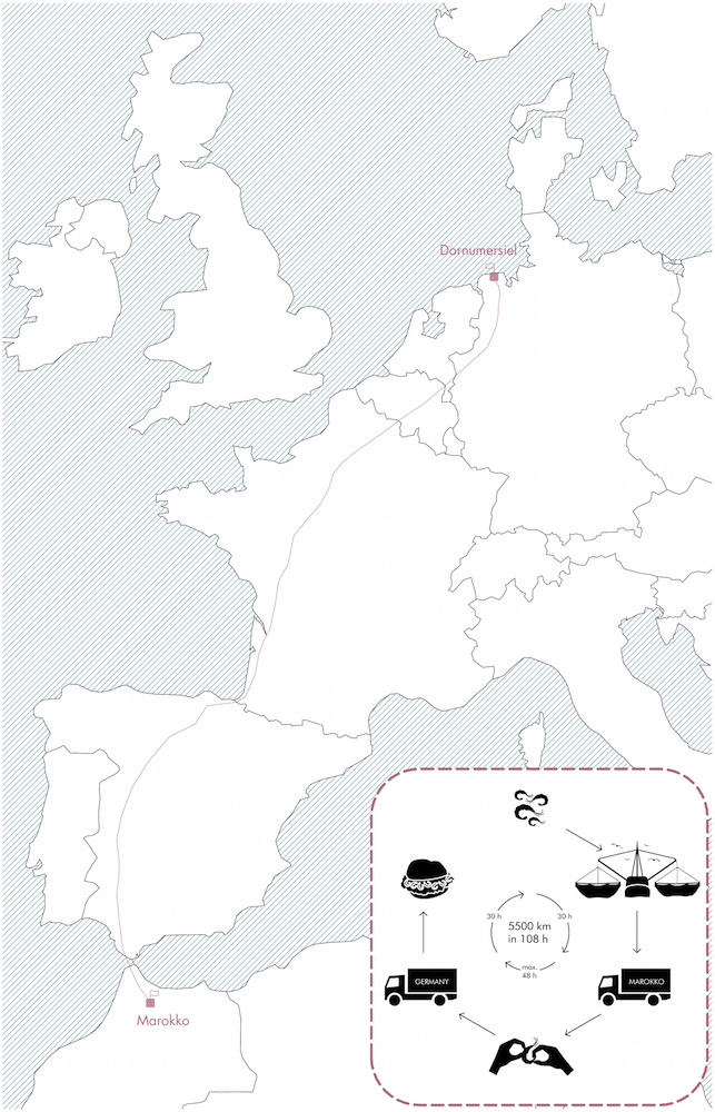
An interesting finding was the social and economic impact of EU regulations and economic forces on fishery. In former times, the crabs fished in the North Sea where peeled at many home kitchens in the villages. Due to laws on hygienic standards (requirement of steel kitchens) this was no longer permitted. Instead, the crabs are now driven by trucks to Morocco, get peeled there at a low price and are transferred back. At the harbor in Dornumersiel you can buy crab rolls, but these crabs are most likely 3 weeks old and you will never find out, if they were fished locally. (> Image 5)
Structural changes have caused a loss of jobs in the community and many inhabitants commute to work in close by towns like Aurich, Norden, Leer, Emden or Wilhelmshaven. Here, they also use the infrastructure for e.g.services, shopping and leisure. Many small scale local businesses in Dornum do not exist anymore.
Places of social gathering have vanished. The usage of television, internet and new media changes lifestyles and social contacts. The life of people takes place not only at their surrounding physical space, but also on a virtual, global level. On the other hand, civil engagement is quite visible in many clubs and association like the Heimatvereine, sport clubs, voluntary fire brigade and others. The effects of demographic changes – older, less, more diverse – can be observed in Dornum. The influence of the high number of incoming tourists is undeniable, some of them having chosen the community as secondary residence. Coming along with this development, we recognized also fear – fear of being not attractive enough for the younger people, fear of not being able to provide services for the older ones, fear of losing social cohesion.
The territory is integrated in trans-local and global networks. Namely there are the UNESCO heritage site and other nature protection areas, energy production and consumption grids, the industrialized food production, the competition of touristic destinations and there are global players like Enercon or Volkswagen as main employers in the area. Globalization is present. Even the Pacific oyster has settled in the Wadden Sea, the ecosystem is highly affected by mankind.
The space of the territory is strictly allocated to the different uses: agriculture, fishing, energy production, nature protection, settlement, infrastructure, tourism and leisure. Conflicts on space allocation are continuously going on. The community is competing for inhabitants, tourists and investments. However, the development of the cultural landscape and spatial issues play a minor role in discussions, in spite of considerable problems with aesthetics and identity.
The adventurous and vast raw nature of the Wadden Sea is marketing instrument to attract people. But during summer the beach area turns into a colorful fun park for mass tourism. The protection and education mandate of the UNESCO can hardly be implemented. Temporal stands – Budenzauber – draw attention and obstruct the view towards grown structures. Vacancies are visible but unacknowledged. To prolong the touristic seasons plans for an artificial indoor harbor are favored. Secondary homes, built in a row behind the dyke (the closeness to the water has become essential), creating a random new urban pattern, mock all discussions on building culture. Recently constructed community houses, which are in fact sheds, captivate us with unbelievable sadness.
(Images 6 - 8)
Envisioning a new rural-urban territory
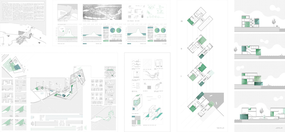
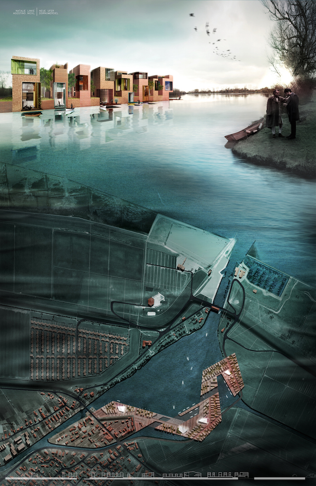
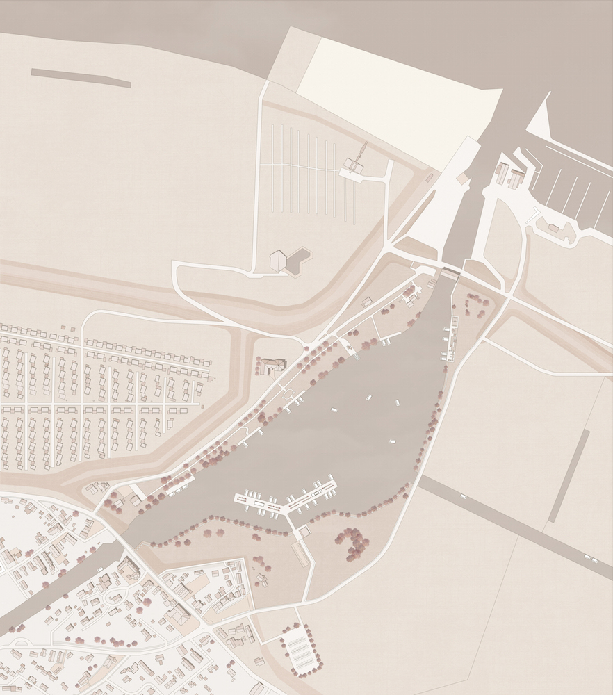
Continuing a phase of intensive field research, we worked with students in an urban design studio on the enlargement of the harbor village of Dornumersiel. The site is located at the shore of a sweet water lake between the tidal gate and harbor in the north and the village core in the south. In the design studio we discussed possible functions, types of housing, the strengthening of infrastructural links and the relation to the landscape as well as the challenges and potentials of seasonality and public space. We discussed the integration of various stakeholders and users and the possible engagement of the local population. In the recent discussion about `space pioneers´(Raumpioniere) it is pointed out, that the spatial practice of self-organization can be a successful alternative to a consumer-oriented expectation of `equal living conditions´ provided by the state (Germany) at any given place [3]. The specific solutions, developed by space pioneers, often follow the logic of places and strengthen its potentials and identity [4]. In this sense we developed with the students alternatives to touristic theme parks and generic suburban extensions.
The territory is not rural anymore in a historical sense. This new type of space has been called `rurban´ – the rural areas are connected up to the global scale with the urban in a complete new way [5]. In Dornum this has the effect of losing ties and of a nebulous future. With the design projects we tested, how a new rural-urban territory can look like in the future. We tried to detect synergies with a new vision and narrative of the cultural landscape, embracing the present transformations, trends and stakeholders. Regarding the future development, we argue for a sense and quality of place. The aim is to raise awareness for the foundations and for the creation of attractive and sustainable living conditions for different users. The results of the design studio add to a general discussion about the role of regional building and building culture today and about possible visions for a new rural-urban territory and cultural landscape. (Images 9 - 18)
BIBLIOGRAPHY
Faber, K.; Oswalt, P., (ed., 2013). Raumpioniere in ländlichen Regionen - Neue Wege der Daseinsvorsorge.
Spector Books: Dessau.
Küster, H. (2013). Geschichte der Landschaft in Mitteleuropa – Von der Eiszeit bis zur Gegenwart. C.H. Beck: München.
Landwirtschaftskammer Niedersachsen (ed., 2011). Agrarstatistisches Kompendium 2011 - Struktur und Entwicklung der niedersächsischen Landwirtschaft in Zahlen und Beiträgen. Willers Druck: Oldenburg.
Pretterhofer, H., Spath, D., Vöckler, K., (2010). Land - Rurbanismus oder Leben im postruralen Raum. Haus der
Architektur: Graz.
Footnotes
[1] See Küster, H. (2013), pp 141-155, 221-230.
[2] See Landwirtschaftskammer Niedersachsen (ed., 2011), tables 2.1.3 Entwicklung der durchschnittlichen Betriebsgröße in den Landkreisen und kreisfreien Städten 1979 – 2010, 2.1.8 Entwicklung der Anzahl landwirtschaftl. Betriebe in Niedersachsen nach Größenklassen
[3] See Matthiessen, U.. Raumpioniere und ihre Möglichkeitsräume. In Faber, K.; Oswalt, P., (ed., 2013), pp 153-160.
[4] Ibid. p 157.
[5] See Pretterhofer, H., Spath, D., Vöckler, K., (2010), p 17.


EWT/ EcoWebTown 10-11, II-III 2014
Magazine of Sustainable Design
(Quadrimestrale on line sul progetto di città sostenibile)
Edizione SCUT, Università Chieti-Pescara
Registrazione al tribunale di Pescara n. 9/2011 del 07/04/2011